This forum is preserved as a permanent archive. The community continues at eMedia Press.

Announcement

Collapse
No announcement yet.

North - South

Collapse
X
 
  • Filter
  • Time
  • Show
Clear All
new posts

  • A woman named Lady Bount was among the first to peer review Rowbotham's work:

    "The Old Bedford Level was the scene of further experiments over the years, until in 1904, photography was used to prove that the earth is flat. Lady Blount, a staunch believer in the zetetic method hired a photographer, Mr Cifton of Dallmeyer's who arrived at the Bedford Level with the firm's latest Photo-Telescopic camera. The apparatus was set up at one end of the clear six-mile length, while at the other end Lady Blount and some scientific gentlemen hung a large, white calico sheet over the Bedford bridge so that the bottom of it was near the water. Mr Clifton, lying down near Welney bridge with his camera lens two feet above the water level, observed by telescope the hanging of the sheet, and found that he could see the whole of it down to the bottom. This surprised him, for he was an orthodox globularist and round-earth theory said that over a distance of six miles the bottom of the sheet should bemore than 20 feet below his line of sight. His photograph showed not only the entire sheet but its reflection in the water below. That was certified in his report to Lady Blount, which concluded: "I should not like to abandon the globular theory off-hand, but, as far as this particular test is concerned, I am prepared to maintain that (unless rays of light will travel in a curved path) these six miles of water present a level surface."

    Mrs. Peach recently found a reference of photographic evidence from The English Mechanic, a scientific journal:

    "The Flat Earth: another Bedford Canal experiment" (Bernard H.Watson, et al), ENGLISH MECHANIC, 80:160, 1904

    Bedford Canal, England. A repeat of the 1870 experiment. "A train of empty turf-boats had just entered the Canal from the river Ouse, and was about proceeding to Ramsey. I arranged with the captain to place the shallowest boat last in the train, and to take me on to Welney Bridge, a distance of six miles. A good telescope was then fixed on the lowest part of the stern of the last boat. The sluice gate of the Old Bedford Bridge was 5ft. 8in. high, the turf-boat moored there was 2ft. 6in. high, and the notice board was 6ft. 6in. from the water. The sun was shining strongly upon them in the direction of the south-southwest; the air was exceedingly still and clear, and the surface of the water smooth as a molten mirror, so that everything was favourable for observation. At 1.15 p.m. the train started for Welney. As the boats gradually receded, the sluice gate, the turf-boat and the notice board continued to be visible to the naked eye for about four miles. When the sluice gate and the turf-boat (being of a dark colour) became somewhat indistinct, the notice board (which was white) was still plainly visible, and remained so to the end of six miles. But on looking through the telescope all the objects were distinctly visible throughout the whole distance. On reaching Welney Bridge I made very careful and repeated observations, and finding several men upon the banks of the canal, I called them to look through the telescope. They all saw distinctly the white notice board, the sluice gate, and the black turf-boat moored near them.'

    Now, as the telescope was 18in. above the water, The line of sight would touch the horizon at one mile and a half away (if the surface were convex). The curvature of the remaining four miles and a half would be 13ft. 6in. Hence the turf-boat should have been 11ft., the top of the sluice gate 7ft. 10in., and the bottom of the notice board 7ft. below the horizon.

    My recent experiment affords undeniable proof of the Earth's unglobularity, because it rests not on transitory vision; but my proof remains printed on the negative of the photograph which Mr.Clifton took for me, and in my presence, on behalf of J.H.Dallmeyer, Ltd. A photograph can not 'imagine' nor lie!".


    Flat Earth from a plane on a plain
    Flat Earth an artist perspective on Polaris
    Come fly with me into reality
    Amazing flight of a ballon to the edge of space
    Last edited by cikljamas; 10-19-2014, 08:46 AM.
    "There is no love without prayer - there is no prayer without forgiveness because love is prayer - forgiveness is love." Virgin Marry - Immaculate Conception ...The geologists say it's not in the ground, the airforce says it's not in the air, the astronomers say it's not from space, so we are running out of options...

    Comment


    • September | 2011 | Polar Field Services

      The above Star-Trails "showing" the North Pole are from Greenland,
      Master @cikljamas do you agree?

      Also, at the North Pole how high is Polaris?


      Al

      Comment


      • When you talk to yourself

        When you post 5 posts in a row repeating the same nonsense over and over....


        is this


        1. an attempt to convince others ? (no chance anyone is buying it)

        or as I suspect....


        2. an attempt to convince yourself.

        Comment


        • What a flat horizon...

          Why isn't it curved as shown in the fig. 20 instead of being flat as shown in fig. 19? Why isn't it case in any case? Why don't we see always curved horizon instead of always seeing it perfectly flat?

          The only thing that is curved is space shuttle contrail - this time viewed from 30 000 ft


          Flat Earth Response Video To Everyone its so flat__________________________

          ISIS warrior, don't you dare to believe your eyes!!!
          "There is no love without prayer - there is no prayer without forgiveness because love is prayer - forgiveness is love." Virgin Marry - Immaculate Conception ...The geologists say it's not in the ground, the airforce says it's not in the air, the astronomers say it's not from space, so we are running out of options...

          Comment


          • Originally posted by cikljamas View Post


            Concave Earth Theory - The Wild Heretic


            Al

            Comment


            • [QUOTE=cikljamas;264185]


              your self delusion knows no boundary.


              Something on the order of 10,000 satellites say you are without ANY DOUBT,....... full of "IT"


              Comment


              • Creationists who are not geocentrists are even more pathetic and sad guys than heliocentrists are, geocentrists who decline to accept FET are even more sad and pathetic guys than Creationists are, and what to say about concave earth believers? They are either plain stupid or plain evil disturbers in mission to deliberately distract and divert people's attention into wrong direction and to make troubles just like Theoria-ISIS-warrior-troublemaker does throughout this thread.

                Example NO 1:

                Have you ever seen the Southern Cross (constellation Crux) from 28 degrees north? This is perhaps a northern most record to capture the complete view of this small but notable southern constellation. This time-lapse video shows stars moving over the southern horizon of Tenerife, Canary Islands. The video is made of a sequence of many short-exposure images. As added by the photographer "The video is the result of nearly two hours of continuous shots. To my knowledge this is the first ever imagery of full Southern Cross, including the lower star Acrux from this northern latitude. I was at Teide National Park at altitude of 2300 meters, probably the place with darkest and most transparent sky on the island. The atmospheric physics contained in this view is interesting too. However, due to atmospheric refraction and the high altitude, the star is visible only for a few minutes in mid-May in early evening. and practically.

                No "altitude" or/and "refraction" excuse will suffice to cover up the only possible solution that we can use to convincingly explain this phenomena, and that one and only convincing explanation is of course FLAT EARTH theory and nothing but the FLAT EARTH obvious fact
                Example NO 2:

                Thanks to the refraction of sunlight in the atmosphere, the midnight sun can also be seen south of the Arvidsjaur and Haparanda[QUOTE][QUOTE=cikljamas;260785]
                Example NO 3:


                The North Star can even be seen slightly south of the Equator (because of atmospheric refraction) (wiki quote)


                And now something that you didn't notice in the first post on this page:

                A woman named Lady Bount was among the first to peer review Rowbotham's work:

                "The Old Bedford Level was the scene of further experiments over the years, until in 1904, photography was used to prove that the earth is flat. Lady Blount, a staunch believer in the zetetic method hired a photographer, Mr Cifton of Dallmeyer's who arrived at the Bedford Level with the firm's latest Photo-Telescopic camera. The apparatus was set up at one end of the clear six-mile length, while at the other end Lady Blount and some scientific gentlemen hung a large, white calico sheet over the Bedford bridge so that the bottom of it was near the water. Mr Clifton, lying down near Welney bridge with his camera lens two feet above the water level, observed by telescope the hanging of the sheet, and found that he could see the whole of it down to the bottom. This surprised him, for he was an orthodox globularist and round-earth theory said that over a distance of six miles the bottom of the sheet should bemore than 20 feet below his line of sight. His photograph showed not only the entire sheet but its reflection in the water below. That was certified in his report to Lady Blount, which concluded: "I should not like to abandon the globular theory off-hand, but, as far as this particular test is concerned, I am prepared to maintain that (unless rays of light will travel in a curved path) these six miles of water present a level surface."


                So, what is going to be: refraction hoax or reflection fact??? What do you think? How come that on the Lady Blount's photograph we can't see refraction of the reflection?


                edit: oh, i forgot this:

                The distance to the north star was recently downgraded from 424 light years to 324 years (which shows scientists still hold no key to the universe)... 100 light years more or less, does it make any difference? It's so trivial, isn't it???

                Research reported in Science suggests that Polaris is 2.5 times brighter today than when Ptolemy observed it, changing from third to its current second magnitude.[14] Astronomer Edward Guinan considers this to be a remarkable rate of change and is on record as saying that "If they are real, these changes are 100 times larger than [those] predicted by current theories of stellar evolution." ... Just 100 times larger than predicted by current Theories-ISIS-troublemakers, it's so trivial, isn't it?
                Last edited by cikljamas; 09-16-2014, 09:22 AM.
                "There is no love without prayer - there is no prayer without forgiveness because love is prayer - forgiveness is love." Virgin Marry - Immaculate Conception ...The geologists say it's not in the ground, the airforce says it's not in the air, the astronomers say it's not from space, so we are running out of options...

                Comment


                • Why is Antarctica nothing alike Arctic?

                  Excerpt from a 1947 newspapers article "MAN AGAINST ICE" (OPERATION HIGH JUMP) :

                  EXPLORERS have found it cruel and rugged, colder than the Arctic by an average of 40 degrees, and swept by pounding gales and blinding snowstorms. It is described as the and within its confines there is practically no animal life and an even greater scarcity of plant life. the top of the world has been almost a balmy tropical paradise compared to the Antarctic. Although there is practically no animal life on Antarctica, within the corresponding area around the North Pole there are year-round residents the musk ox, polar bear, fox, wolf, Arctic hare, reindeer, seal and walrus. Life on Antarctica normally is restricted to its ice-bound shore line, with birds and seals its only continuous inhabitants.

                  Although the Arctic regions abound with several hundred species of flowering plants and ferns, the Antarctic supports only two forms of tufted grass, and these cannot by any stretch of the imagination be said to flourish. This poverty of plant life on the continent is due, fundamentally, to a low mean temperature. Many of the charted peaks tower higher than Mt. McKinley, highest mountain in the U.s. The South Polar plateau is about 10,000 feet above sea level.

                  and possibly, indirectly, that of the entire worldDuring the 1933-35 expedition, 8,000 bergs were sighted in one 24-hour period.

                  The expedition will take full advantage of the photographic developments achieved during World War II, and in addition will have the advantage of the trimetrogon camera. This is a three-in-one camera which takes a vertical shot to cover what is beneath the plane, and also two oblique shots to give a continuous photographic image from horizon to horizon. The pictures will be taken continuously to give a complete photographic coverage of the territory traversed by the planes. These photos of a large section of Antarctica the expedition expects to explore two million square miles from the air will show the general contours of the land, mountain ranges, glaciers and ice fields. Also, they will give a general picture of what any ground parties might encounter. The Antarctic coast will be outlined also, in many places for the first time.

                  The expedition doesn't expect the interior of the continent to be featureless, even though it is described as a frigid, barren waste land. It is expected that many new mountain ranges will be discovered. The explorers want to know the character of these strange, unknown lands. Only about a tenth of the continent has been sighted, and of that, only a small portion photographed. Aside from pemmican, standard polar item, no special foods were taken. The food is standard, including huge quantities of quick-frozen foods. Because the party will be away from civilization for four to five months it is anticipated that the ships will have to push their way out of the pack ice by the end of March, arriving home in late April
                  Many things in above article perfectly fit with FET!

                  The fourth culminating expedition, Operation Highjump, was the largest Antarctic expedition to date. The total number of personnel involved was over 4,000. The armada arrived in the Ross Sea on December 31, 1946, and made aerial explorations of an area half the size of the United States, recording ten new mountain ranges. The major area covered was the eastern coastline of Antarctica from 150 degrees east to the Greenwich meridian. The expedition was terminated abruptly at the end of February 1947, two to four months early...
                  Question 1: Why?

                  Question 2: Why there is still (not even today) no compelling answer to above "Why" question?

                  Question 3: Is this just strange coincidence:

                  The current United Nations emblem was approved on 7 December 1946.

                  The current United Nations flag was approved on 20 October 1947.

                  Conclusion:

                  There is no doubt that the retarded "hallow earth" (plus UFO-Third Reich alleged South Pole military bases science-fiction idiotisms) hoax theory has been using with the purpose of covering up the truth that there is no South Pole whatsoever!!!

                  Last edited by cikljamas; 09-16-2014, 03:38 PM.
                  "There is no love without prayer - there is no prayer without forgiveness because love is prayer - forgiveness is love." Virgin Marry - Immaculate Conception ...The geologists say it's not in the ground, the airforce says it's not in the air, the astronomers say it's not from space, so we are running out of options...

                  Comment


                  • Originally posted by cikljamas View Post
                    [B]
                    plus UFO-Third Reich alleged South Pole military bases science-fiction idiotisms) hoax theory has been using with the purpose of covering up the truth that there is no South Pole whatsoever!!!


                    Youre funny


                    Now its a Nazi conspiracy

                    Comment


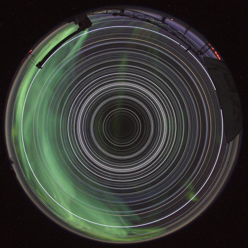
                    • APOD: 2012 August 2 - South Pole Star Trails

                      Explanation: No star dips below the horizon and the Sun never climbs above it in this remarkable image of 24 hour long star trails. Showing all the trails as complete circles, such an image could be achieved only from two places on planet Earth. This example was recorded during the course of May 1, 2012, the digital camera in a heated box on the roof of MAPO, the Martin A. Pomerantz Observatory at the South Pole. Directly overhead in the faint constellation Octans is the projection of Earth's rotational axis, the South Celestial Pole, at the center of all the star trail circles. Not so well placed as Polaris and the North Celestial Pole, the star leaving the small but still relatively bright circle around the South Celestial Pole is Beta Hydri.

                      The above Star-Trails showing the South Pole are from the Martin A. Pomerantz Observatory at the South Pole,
                      Master @cikljamas do you agree?


                      Al

                      Comment


                      • I am prepared to maintain that (unless rays of light will travel in a curved path) these six miles of water present a level surface."
                        You honestly think that defines earth? 6 miles? Its laughable.
                        The earth is 25,000 miles round.

                        The dirt of earth is maluable. Some parts rigid...some parts FLAT.
                        It could VERY easily be a 6 mile stretch of flat land formation that water is laying on.

                        Why has NO ONE EVER repeated this experiment on the ocean?
                        Drive two sail boats miles apart, take telescope with camera, EASY to prove a flat earth.
                        Both boats should be fully visible.

                        Funny...NO ONE CAN PROVE IT...Because the earth isn't flat.

                        Comment


                        • Originally posted by ethan
                          Why has NO ONE EVER repeated this experiment on the ocean?
                          Well in fact, I have, but not on the ocean. On Lago di Garda in Italy.
                          That is quite a big lake, and when I was 15-19 years old, I used to go there wind surfing.
                          When you cross the lake (I thinks that would be more than 6 miles, but I am not sure), you see the beach where you left disappear below the water and the beach that you are heading for rise above the water.

                          Talking about first rate and third rate evidence, I would call the blurred picture from someone long ago (why isn't there a recent picture?) fourth rate evidence and having it seen with my own eyes that I would call first rate evidence.

                          But this whole discussion here is nonsense, because it is not about facts, it is about faith. You can present any fact that proves that the Earth is spherical but it will not be accepted. Only poor executed experiments based on illusion/delusion that seem to prove a flat Earth, those will be accepted.
                          This discussion is utterly useless, you'll have more success teaching pigs to play the violin.


                          Ernst.

                          Comment


                          • Sadly but It is true that we could much easier teach the pig how to play violin than to receive acknowledgment from certain kind of people that the obvious facts are indeed the facts.

                            Haven't we been through all this several times in this thread?

                            First time: page 2 post # 39

                            Second time: page 6 post # 170

                            Third time: page 7 post # 188

                            In addition:

                            1. Why Bedford level experiments were (are) so important?

                            I've recreated the Bedford Level Experiment < danielFES > 11/18 14:32:59

                            I follow the tenets of Zetetic Astronomy and I have conducted my own experiment. Or rather, I recreated the experiment that Samuel Rowbotham conducted in the mid-19th Century which provided evidence of a Flat Earth. If you'd like more detail about the experiment, do a Wikipedia search for "Bedford Level Experiment". But as a quick summary:

                            If the Earth is a sphere which followed the mainstream model of gravity, a still body of water would have a measurable curvature. As an object travels away from you on the surface of the water, it should gradually "sink" until it eventually disappears below the horizon. The amount of drop would be predictable based on the presumed size of the Earth's sphere. On a flat Earth, this curvature would not be present.

                            Long stretches of smooth, relatively still water are difficult to come by. Thankfully, there is a canal in Welney, England which is quite still, very straight and over 6 miles long. Over that 6 miles, a spherical Earth should produce a significant drop. When I conducted the experiment, I did not observe a drop which was in any way consistent with a spherical Earth model. Daniel Shenton
                            What to say about this:

                            In November 2009 Daniel Shenton, the President of the Society wrote to Welney Parish Council requesting permission to display a plaque on the Bedford Bridge commemorating the 1838 experiment. The matter was discussed at the Council's meeting in December 2009 and it was suggested he should contact the Highways dept [of Norfolk CC] who have jurisdiction over such matters. You can read more at item 11g in the Council's minutes. At the same meeting a letter from Russell Duffy regarding Mr Shenton's request was discussed. See item 11i in the same minutes.

                            Shortly after posting this update I learned that the Parish Council should have told Mr Shenton to contact the Bridges Department [of NorfolkCC] as it is they that deals with such matters, not Highways.
                            2. Experiments in California Monterey Bay


                            I live along the California Monterey Bay. It is a relatively long bay that sits next to the Pacific Ocean. The exact distance between the extremes of the Monterey Bay, Lovers Point in Pacific Grove and Lighthouse State Beach in Santa Cruz, is 33.4 statute miles. See this map.

                            On a very clear and chilly day it is possible to see Lighthouse Beach from Lovers Point and vice versa. With a good telescope, laying down on the stomach at the edge of the shore on the Lovers Point beach 20 inches above the sea level it is possible to see people at the waters edge on the adjacent beach 33 miles away near the lighthouse. The entire beach is visible down to the water splashing upon the shore. Upon looking into the telescope I can see children running in and out of the water, splashing and playing. I can see people sun bathing at the shore and teenagers merrily throwing Frisbees to one another. I can see runners jogging along the water's edge with their dogs. From my vantage point the entire beach is visible.

                            IF the earth is a globe, and is 24,900 English statute miles in circumference, the surface of all standing water must have a certain degree of convexity--every part must be an arc of a circle. From the summit of any such arc there will exist a curvature or declination of 8 inches in the first statute mile. In the second mile the fall will be 32 inches; in the third mile, 72 inches, or 6 feet, as shown in this chart. Ergo; looking at the opposite beach 30 miles away there should be a bulge of water over 600 feet tall blocking my view. There isn't.

                            Suppose that the earth is a sphere with a radius of 3,963 miles. If you are at a point P on the earth's surface and move tangent to the surface a distance of 1 mile then you can form a right angled triangle as in the diagram.

                            Looking over a distance of 1 mile, we can use the theorem of Pythagoras:

                            a2 = 3,9632 + 12 = 15,705,370

                            and when we square root that figure we get a = 3,963.000126 miles

                            Thus your position is 3,963.000126 - 3,963 = 0.000126 miles above the surface of the earth.

                            0.000126 miles = 12 in * 5,280 ft * 0.000126 mi = 7.98 inches

                            Hence after one mile the earth drops approximately 8 inches.

                            Ergo, looking across 30 miles the Pythagorean theorem becomes:

                            a2 = 39632 +302 = 15,706,269

                            and when we square root that figure we get a = 3,963.113549 miles

                            Thus your position is 3,963.113549 - 3,963 = 0.113549 miles above the surface of the earth

                            0.113549 miles = 5,280 ft * 0.113549 mi = 599.53872 feet

                            Hence after 30 miles the earth drops approximately 600 feet.

                            Whenever I have doubts about the shape of the earth I simply walk outside my home, down to the beach, and perform this simple test. The same result comes up over and over throughout the year under a plethora of different atmospheric conditions.

                            There are a number of different methods to calculate the drop of the Round Earth. Go ahead and look some up try a few out. You will find that the drop while looking over 30 miles is on the order of 600 feet.

                            3. Experiments on Lake Michigan : The Cellular Cosmogony: Experiments on Lake Michigan

                            4. Some theory :
                            Ships appear to sink as they recede past the horizon

                            5. Nikon Coolpix P510 zoom test (ship at the sea)

                            Nikon Coolpix p500 zoom test shown illustrated with 9 pictures in a row:


                            Osborne Brothers - Rocky Top - YouTube
                            Last edited by cikljamas; 09-17-2014, 12:54 PM.
                            "There is no love without prayer - there is no prayer without forgiveness because love is prayer - forgiveness is love." Virgin Marry - Immaculate Conception ...The geologists say it's not in the ground, the airforce says it's not in the air, the astronomers say it's not from space, so we are running out of options...

                            Comment


                            • Originally posted by cikljamas View Post
                              Whenever I have doubts about the shape of the earth I simply walk outside my home, down to the beach, and perform this simple test.

                              Youre a case study in self-reinforcing delusional fantastical mental machinations.


                              No offense, seek help

                              Comment


                              • Originally posted by cikljamas View Post
                                Suppose that the earth is a sphere with a radius of 3,963 miles. If you are at a point P on the earth's surface and move tangent to the surface a distance of 1 mile then you can form a right angled triangle as in the diagram.
                                Looking over a distance of 1 mile, we can use the theorem of Pythagoras:

                                a2 = 3,9632 + 12 = 15,705,370

                                and when we square root that figure we get a = 3,963.000126 miles
                                Now I see, a sun travels around a pole with an attitude at 100-3000 miles on 6000 miles radius.


                                And since the above involved the Shackleton crater on the moon and Ernest Shackleton explored the South Pole on Earth,
                                it reminded me of this unusual photo taken at the South Pole near the time of the summer solstice
                                (a photo I've posted here a couple times in the past...but it's an oldie but goodie imo) of our home star, the Sun.
                                It shows the time in Antarctica when the Sun never sets below the horizon:


                                Caption:Time-lapse photography. Taken between July 21st, 1900 hrs and July 22nd, 1800 hrs.
                                It is a 360 degrees panorama showing the sun's cycle North of the Arctic Circle.
                                The location is the island of Loppa in Norway.


                                Classroom resources for History and Geography learners: The midnight sun - El sol de medianoche


                                Master @cikljamas, are above renderings panoramic sun-paths?

                                Why a sun is so low and visible from 6000 miles?

                                Why a sun does not hide below a horizon?


                                Al

                                Comment

                                Working...
                                X